








By Shashi P.B.B. Malla
Our land borders with China were negotiated and demarcated in the 1960s and we have no boundary dispute with our northern neighbour.
Our borders with our southern neighbour were regulated by the Treaty of Segauli, 1815 with the then British East India Company. After India’s independence, several border disputes have erupted.
The most serious is in the western sector. Here the River Mahakali is supposed to be the demarcation line between Nepal’s far-western districts of Darchula, Baitadi, and Dadeldhura, and the Indian state of Uttarkhand.
After India’s humiliating defeat in the Sino-Indian War of October 1962, King Mahendra had allowed India to establish a checkpost in Kalapani. Subsequent Nepalese governments failed to request India to vacate the checkpost, nor did they undertake any action to again take physical control of the area.
With time on their side, India thus came to consider Kalapani as their very own, especially since it had geo-strategic implications so close to the sensitive Indo-Chinese border.
 The disputes over Lipulekh and Limpiyadhura arose due to differences of opinion over the actual headwaters of the Mahakali – which would be the demarcation line according to the Segauli Treaty.
India, of course, chose what was favourable to it and established ‘realities’ on the ground – physical presence. All Nepalese governments right up to the second decade of the 21st Century did nothing – they were ‘sleeping’!
In November 2019, India unilaterally released a new political map incorporating Kalapani, Lipulekh and Limpiyadhura areas within its own territory.
This was undoubtedly one-sided and against the norms of international law and constituted – cartographical aggression.
But wonder of wonders, the government of K.P. Sharma Oli suddenly woke up.
However, without exhausting all diplomatic means or at least attempting the last resort of international arbitration, the Oli government chose what it thought was the easy way out.
It claims that the Indian government categorically refused to entertain Nepal’s concerns over the map, and in a tit-for-tat move, itself unveiled a new map of Nepal in May 2020 incorporating all the three areas in question. This added a pointed spur on the northwest corner of Nepalese territory.
For added legitimacy, the Nepalese Parliament unanimously endorsed the new map on June 13, 2020.
All this would have unintended consequences.
India, of course, rejected Nepal’s claims.
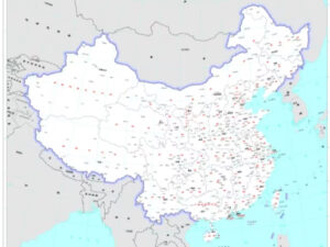
And now China has released its own political map, showing all the territories bordering the country.
The pointed spur in Far Western Nepal is notably absent in the 2023 edition of China’s standard map officially published on the website of China’s Ministry of Natural Resources.
It seems that Beijing’s decision to use the old Nepal map has caused any amount of consternation in Kathmandu and also created doubts about the validity of the 2020 new map of Nepal (The Kathmandu Post, Aug. 31).
But there is no earthly reason for Beijing to get involved in another neighbourly bilateral quarrel.
After all, China has a common land border with 14 other states, and a maritime border with 7 further countries – some of which are disputed and unresolved.
If “the government of Nepal unequivocally believes that this map [Nepal’s own] must be respected by our neighbours as well as the international community’ (Ministry of Foreign Affairs statement), than the government should pursue a more proactive foreign policy and not a reactive one.
It does not help matters, if second rung national leaders like Kathmandu mayor Balen Shah suddenly, singlehandedly and unilaterally cancels a long-planned official visit to China – further muddying the waters!
However, it is important to remember that the “map mess” is of our own making, and successive governments, including those of the Panchayat era and the ‘new democratic period’ are equally to blame.
Neither breast-beating or hyper-nationalism will help us further.
The only way for legitimacy and recognition is international arbitration.
The writer can be reached at: shashipbmalla@hotmail.com
The views expressed in this article are the author’s own and do not necessarily reflect People’s Review’s editorial stance.

Login to add a comment