







By Our Reporter
The Bhotekoshi disaster has exposed a reality that South Asia has been slow to accept: when nature moves across borders, disaster management cannot stop at the border.
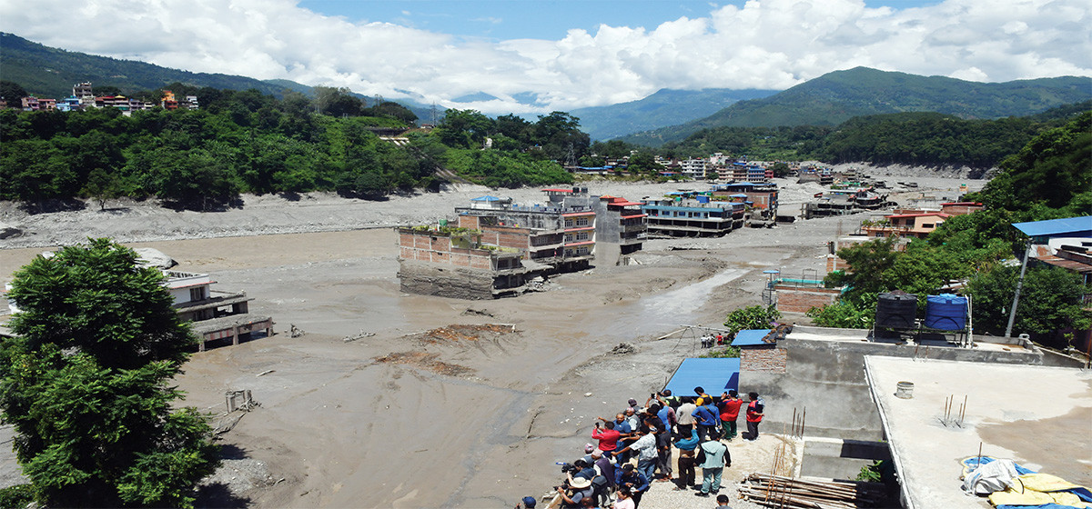
The devastating flood in Nepal’s Rasuwa district was linked to a glacial avalanche and the collapse of ice and rock in the Himalayan region of Xizang. Whatever the final scientific e (Tibet) xplanation may be, one fact is already clear: an event that began in a remote, high altitude area outside Nepal produced deadly consequences deep inside Nepal.
Nepal paid the immediate price in lives, infrastructure and economic losses. But the lesson is not only for Nepal. It is equally relevant to China, India, Bhutan, Pakistan and Bangladesh, countries connected by the rivers and mountains of the Hindu Kush Himalaya.
Mohammad Farooq Azam, a senior cryosphere specialist at ICIMOD, has pointed to the growing frequency of cryosphere related hazards and warned that the pace of change is becoming too rapid for existing systems to keep up. His call for stronger regional cooperation should be taken seriously.
The Himalayan environment does not recognise political boundaries. Glaciers do not stop at a border. Landslides do not wait for permission to cross into another country. Rivers certainly do not care where one country’s territory ends and another begins.
That makes the current approach to disaster preparedness inadequate. Nepal, China and India have their own monitoring systems, government agencies and scientific institutions. But a flood or glacial avalanche originating in one country can leave people in another country with only minutes or hours to respond. If information remains trapped within national institutions, the countries downstream are left reacting after the danger has already arrived.
The Bhotekoshi event should therefore lead to a serious discussion about a regional early warning system for Himalayan hazards.
Such a system should begin at the source. Glaciers, glacial lakes, unstable slopes, snow cover, rainfall and river levels in high risk areas need continuous monitoring. Data should then be shared rapidly with downstream countries. Satellite imagery, ground sensors, weather stations and river gauges can provide valuable information, but only if governments are willing to share it quickly.
The same principle applies in the other direction. Nepal’s rivers eventually flow into India. The Koshi is the clearest example. Heavy rainfall, landslides, glacial activity or sudden changes in river conditions in Nepal can create serious consequences downstream in India. A disaster that begins in the mountains of Nepal can become a flood emergency in Bihar.
India therefore has as much reason as Nepal to demand better cross border coordination. The lesson from the Koshi is particularly important. For decades, the river has demonstrated how events in the Himalayan catchment can affect large populations downstream. The issue is not simply how much water enters the river. Sediment, landslides, damaged embankments and sudden changes in river flow can all increase the danger.
The same logic extends beyond Nepal and India. The rivers and mountain systems of the Hindu Kush Himalaya connect a large part of Asia. What happens in the high mountains can affect communities hundreds of kilometres away. Climate change is making this relationship more urgent. Scientists have documented changes in glaciers, snow conditions, permafrost and mountain slopes across the region. But experts are rightly cautious about assigning climate change as the direct cause of a particular disaster without sufficient evidence.
That caution should not become an excuse for inaction. Governments do not need to prove that every flood was caused by climate change before preparing for a warmer and less predictable mountain environment. Risk management should be based on what is already happening and what could happen next.
Regional cooperation, however, requires more than occasional meetings and statements of solidarity. Countries need formal protocols for sharing hazard information, common standards for monitoring, joint scientific research and clear procedures for issuing warnings. Nepal and China, in particular, need stronger arrangements for sharing information about glacial lakes, glaciers and unstable mountain slopes in areas that could threaten downstream Nepali communities. India and Nepal need equally effective arrangements for river and flood information.
A regional emergency mechanism could also help. When a major event occurs, neighbouring countries should know whom to contact, what information to share and how to coordinate rescue, evacuation and humanitarian assistance. Exercises involving disaster agencies from different countries could test whether these systems actually work. Infrastructure planning also needs a regional perspective. Roads, hydropower projects, bridges and settlements should be assessed not only for local hazards but also for risks originating upstream across the border.
The biggest obstacle may not be technology. It may be trust. Countries often treat environmental and hydrological data as sensitive information. But when the information can save lives downstream, excessive secrecy becomes difficult to justify. Sharing a river gauge reading or a warning about an unstable glacial lake should not become a geopolitical problem.
The Bhotekoshi disaster offers a rare opportunity to rethink that mindset. Nepal cannot prevent every glacial avalanche. China cannot stop every mountain from collapsing. India cannot control every river entering its plains. But the countries can work together to ensure that one country’s disaster does not become another country’s surprise. The Himalayas are shared geography. Their risks must be treated as shared risks too.The next disaster may begin in Tibet and strike Nepal. It may begin in Nepal and move towards India. The direction is uncertain. The need for cooperation is not.

Login to add a comment