







By Our Reporter
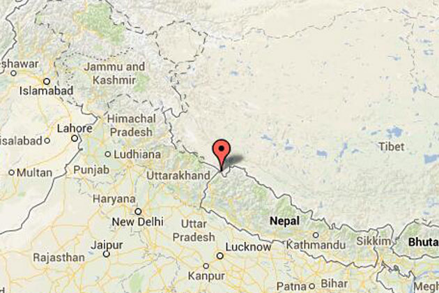
India has again showed its highhandedness over Nepal by issuing a new political map including Nepali territory in India.
When India unveiled its new political map showing 372 km sq of Nepali territory inside India on November 2, Nepali people, political parties, politicians, media and others have shown unprecedented unity to safeguard the national integrity. They have stood together on the issue.
Almost every day from the top politicians to student leaders, from political parties to civil society leader are condemning India for encroaching the Nepali land, bigger than Singapore in size.
They have been exerting pressure on the government to hold high level talks to resolve the border dispute and safeguard Nepali territory.
On Saturday, an all-side meeting of top political leaders and experts called by Prime Minister KP Sharma Oli suggested the government take effective and high level diplomatic initiative to return the Nepali land encroached by India in Kalapani area of Darchula district.
Prime Minister Oli had called the all-party meeting to discuss the new map issued by the Indian government that included Kalapani area of Nepal in India and the situation arisen in Nepal after the issuance of the map. The meeting was attended by all top leaders of all political parties representing the federal parliament and others.
After the meeting that lasted for more than four hours at Prime Minister Oli’s official residence in Balauwatar, Minister for Foreign Affairs Pradeep Kumar Gyawali said that the meeting had made an unprecedented nation al consensus on safeguarding the geographical integrity and national sovereignty.
He said that all political leaders in the meeting said that the Kalapani area, which includes Kalapani, Lipu Lek and Limpiyadhura, is definitely the territory of Nepal.
All the political parties, leaders and experts have given a strong backing to the government to take the initiative for resolving the issue through high-level talks with India, Minister Gyawali said.
He said that the government would soon initiate discussions with India regarding the territorial disputes to find a justifiable solution.
Sher Bahadur Deuba, president of the Nepali Congress, said that Kalapani area is the territory of Nepal and the government should start diplomatic talks to resolve the issue.
Former Prime Minister Dr. Baburam Bhattarai said that the government should start a high-level political dialogue as the technical and bureaucratic mechanism had failed to resolve the long-standing territorial disputes.
NCP chair Pushpa Kamal Dahal, former prime minister Lokendra Bahadur Chand, top leaders of both the ruling and opposition parties, former foreign minister Ramesh Nath Pandey, Rastriya Prajantra Party leader Kamal Thapa, former foreign minister Dr.Prakash Chandra Lohani attended the meeting .
Meanwhile, the State Affairs and Good Governance Committee of the Federal Parliament on Monday directed the government to resolve the issue of Kalapani border with India through the high-level diplomatic and political channels.
After holding discussions with the two ministers, the committee instructed the government to make diplomatic and political approaches to resolve the issue of growing border disputes.
The committee also directed the government to deploy security forces by building barracks in the border areas, including Kalapani, for border security.
During the meeting of the committee, the parliamentarians expressed their concerns over the growing encroachment upon the Nepali territories in various places by India.
The committee further directed the government to submit the report prepared by the Eminent Persons Group (EPG) formed by the two nations to review all the past treaties and agreements reached between Nepal and India, to the concerned party.
Addressing the meeting Nepal Communist Party chair Pushpa Kamal Dahal said that there was no evidence to prove that any former king of Nepal had allowed the Indian Army to enter in the territory of Kalapani and Lipu Lek.
“The historical facts and evidences have proved that Kalapani is the land of Nepal. The Sugauli Treaty has clearly mentioned that Mahakali is the border of Nepal and India. And it is also clear that Limpiyadhura is the source of the Mahakali River. Therefore, the eastern territory of Limpiyadhura is Nepal and western is of India,” he said.
During the meeting Home Minister Ram Bahadur Thapa said the problem had aroused due to the open border with India.
Meanwhile, Minister for Foreign Affairs Pradeep Kumar Gyawali had clarified that the new political map made public by India was not acceptable to Nepal.
Speaking at the International Relations Committee of the House of Representatives also on Monday, Minister Gyawali said that the government was ready for taking diplomatic initiative on the issue.
“I will immediately take an initiative to resolve the problem by keeping in touch with the Ministry of Foreign Affairs of India,” Gyawali told the meeting of the committee.
If needed, high level political dialogue from the Prime Minister level could also begin, he added.
He further said that all the territories of Kalapani are the integral parts of Nepal, and the unilateral decisions could not be accepted.

Login to add a comment