







 By Our Reporter
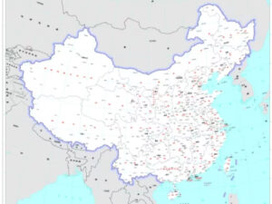
In its latest political map released on Monday last week, China did not recognise Nepal’s latest political map unveiled Nepal’s new political map unveiled by the KP Oli-led government on May 20, 2020 and unanimously endorsed by Parliament on June 13 the same year.
In its new map, China included India’s Arunachal Pradesh and the disputed Aksai Chin area in its territory. The map that shows the territories bordering China has surprisingly not shown the pointed spur of the new Nepal.
With the release of the map, it has now become clear that both China and India did not recognise the map of Nepal issued three years ago.
Why did China not recognise the map, when it showed the Indian territory in its own map?
Two schools of thought have been floated for the dismissal of the official map of Nepal by the northern neighbour.
First, China has an interest in the Nepali land now occupied by India as it has agreed to build a cross-border road through the Nepali land and the road-building work is in progress.
Secondly, the Oli-led government issued the new map, but it did not inform China about the revised map.
Kalapani, Lipulek and Limpiyadhura of Darchula district were missing in Nepal’s map since 1974 were included in the map.
Recently, Foreign Minister Saud said that the Oli-led government did not correspond to China and other nations about the new Nepali map, which resulted in the omission of the pointed spur in China’s latest map. However, former foreign minister Pradeep Gyawali denied the allegations.
But the reality is that the government of Nepal had failed to convince even China that Lipulek, Kalapani and Limphiyadhura fell in Nepal. The past evidence proved that they were Nepali land till 1965.

Login to add a comment